MR JUSTICE ARNOLD :
Introduction
1.
This is a boundary dispute concerning two properties in Lyme
Regis called “Kaduna”, which is owned by the Claimant (“Ms Pollock”), and
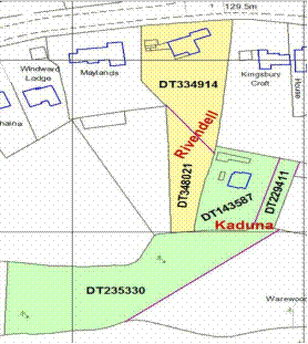
“Rivendell”, which is owned by the Defendants (“the Oldfields”). The location of
the properties is shown in the plan reproduced below.
2.
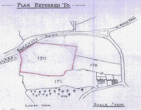
Ms Pollock exchanged contracts to buy Kaduna on 7 March 2014 and
completed on 22 April 2014. When she took possession of the property, she found
that a 6 metre or so high line of hedging plants (including blackthorn and
hazel) and trees along Kaduna’s western boundary had been cut back to the level
of the earth bank on which it grew. Ms Pollock was unhappy about this, and
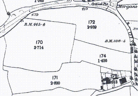
brought a claim against the Oldfields for damages and an injunction on the
basis that the bank and hedge were part of Kaduna. The Oldfields accepted that
the work on the hedge had been carried out by Mr Oldfield and another
neighbour. The Defendants denied any wrongdoing on the grounds that (i) the
bank and hedge were part of Rivendell and (ii) in any event the work had been
done before Ms Pollock acquired any interest in Kaduna.
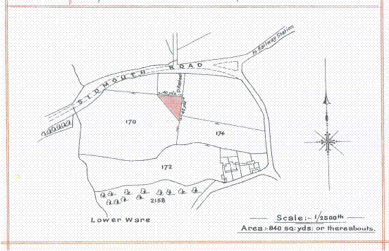
3.
There were three issues at trial. First, where was the boundary between
Kaduna and Rivendell? The boundary area consists of (i) the bank and hedge
which runs between the two properties for a distance of about 30 metres from
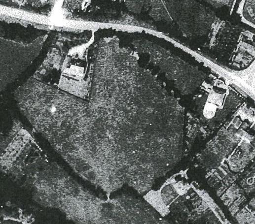
the northern end and (ii) a lonicera hedge without a bank which occupies the
final 12.5 metres or so of the boundary at the southern end. Ms Pollock
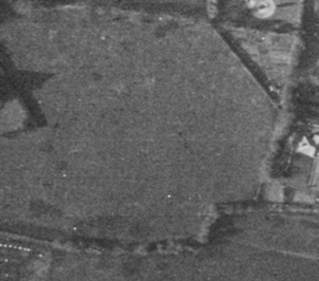
contended that the boundary was to the west of the bank. The Oldfields
contended that the boundary was to the east of the bank. Secondly, when had the
hedge been cut back? Ms Pollock contended that it was in mid-April 2014, the
Oldfields that it was in late February 2014. Thirdly, if the cutting back of
the hedge was wrongful, what was the appropriate relief? Ms Pollock claimed
damages of about £100,000 and an injunction. The Oldfields contended that she
had suffered no loss and no injunction was required.
4.
So far as the boundary issue was concerned, it was common ground at
trial that:
i)
this issue depended on the proper interpretation of a conveyance dated
16 November 1928 (referred to at trial as “the Operative Conveyance”) by which
a field which is now part of Rivendell (Field 170) was transferred out of
common ownership with a field upon part of which Kaduna now stands (Field 174)
following an auction on 26 September 1928;
ii)
the Operative Conveyance was to be interpreted by reference to what a
reasonable person with the document in his hand and all the admissible
information available, which would include the topographical features of the
land at the date of document, would understand it to mean;
iii)
the relevant boundary was marked by a line on a plan attached to the
Operative Conveyance on which there is a “T-mark” indicating that the boundary
feature was owned by the purchaser of Field 170;
iv)
the bank had been there for a very long time, and hence had been present
at the time of the Operative Conveyance; and
v)
the bank had at all material times stopped short of the southern
boundary leaving a gap.
5.
Ms Pollock’s case was that the line on the plan in the Operative
Conveyance represented a stock-proof fence running along the western side of
the bank. The Oldfields’ case was that the line on the plan represented the centre
line of the bank extrapolated to the southern boundary and that, by virtue of
the T-mark, the legal boundary lay along the eastern edge of the bank. Thus a
key factual issue was whether, at the time of the Operative Conveyance, a
stock-proof fence had been in existence to the west of the bank. A related
question was what, if anything, had occupied the gap between the bank and the
southern boundary. Ms Pollock’s case was that the stock-proof fence had
extended to the southern boundary. The Oldfields’ case was that the gap had
been filled by a hedge.
6.
The action was tried by HHJ Parfitt sitting in the County Court at
Central London between 12 December 2016 and 26 January 2017. He had the benefit
of a site visit. In addition to the site visit, the trial took six days, during
which the judge heard evidence from eight witnesses of fact and four experts.
On 6 April 2017 the judge handed down a careful and detailed reserved judgment
running to 105 paragraphs. He concluded that there was no stock-proof fence to
the west of the bank at the time of the Operative Conveyance, and that the
proper interpretation of the Operative Conveyance was that the line on the plan
denoted the bank. Accordingly, he found in favour of the Oldfields on the
boundary issue and dismissed the claim. On the second issue, he found that the
works were done in April 2014 and thus the works would have constituted an
actionable wrong if the hedge had formed part of Kaduna. On the third issue, he
assessed damages at £22,500, but held that an injunction was unnecessary.
7.
Ms Pollock now appeals against the judge’s conclusion on the boundary
issue with permission granted by Snowden J on three out of six proposed grounds
of appeal. There is no challenge by the Oldfields to the judge’s conclusions on
the second and third issues if Ms Pollock succeeds on the boundary issue.
The Operative Conveyance
8.
By the Operative Conveyance, the land which now
comprises the southern garden of Rivendell was conveyed by a Mr Woodroffe to a
Mr Worth as part of Field 170. The parcels clause of the 1928 Conveyance conveyed:
“ALL THAT piece or parcel of land situate on the Sidmouth
Road in the Parish of Lyme Regis in the County of Dorset containing an area of
Three acres two roods and thirty four perches or thereabouts and more
particularly delineated and described on the plan drawn on these presents,
Numbered 170 and surrounded with the colour pink…”.
9.
The plan is reproduced below.
10.
The plan shows a number of T-marks on the boundaries of Field 170,
including a T-mark on the boundary between Field 170 and Field 174 facing
inwards towards Field 170 showing that that boundary was the responsibility of
the owner of Field 170.
11.
Field 171, which contains a woodland plot now
forming part of Kaduna, was separately conveyed by Mr Woodroffe to Mr Worth on
the same day. The main plot at Kaduna, which formed part of Field 174, was conveyed
to a Mr Lane four days later on 20 November 1928.
The documentary evidence
12.
The principal items of documentary evidence which are relevant to
the issue as to whether there was a stock-proof fence to the west of the bank are
as follows.
13.
The 1841 Tithe map. The 1841 Tithe map, which is reproduced below, shows a “tongue” of
land extending from what became Field 170 (then known as 387) into Field 174
(then known as 385). Thus, whilst the bank was probably in place in 1841, no
boundary feature is shown in the gap to the south. The tithe apportionments
record that Field 170 and Field 174 were both arable fields.

14.
The 1890 OS map. By
the time of the 1890 Ordnance Survey (“OS”) map, which is reproduced below, a
re-organisation of the fields had taken place: the “tongue” of Field 170 had
been absorbed into Field 174 and the map shows a boundary feature which extends
all the way to the southern boundary.
15.
Counsel for Ms Pollock submitted that Field 170
had become a pasture field by this date. I was not shown any evidence which
establishes this; but the point does not matter because it is clear (for the
reason explained in paragraph 18 below) that it was a pasture field by 1928.
16.
Subsequent OS maps in 1903 and 1929 (which was
probably based on a survey in 1928) show that Fields 170 and 174 retained the
same basic configuration up until 1928.
17.
The 1890 and 1909 photographs. Two photographs, taken in 1890 and 1909, of other fields nearby in
Lyme Regis, show stock-proof fences in place. In the case of the 1909
photograph, it shows a fence in front of a hedge. The point of this evidence is
simply to show that stock-proof fences were in use in the area in the relevant
period.
18.
The auction particulars. Fields 170, 171 and 174 comprised
three of seven lots sold at auction on 26 September 1928. The
auction particulars described Lot 4 (Field 170) as “a valuable pasture field”, Lot
3 (Field 171) as “pasture land and shed” and Lot 5 (Field 174) as “a very
valuable arable field”. All three fields were sold subject to a tenancy in
favour of a farmer, a Mr Hallett, but he had served notice to quit at 25
December 1928. Lot 2 was a farm which included “Cowstall with 17 tyings”, also
let to Mr Hallett. Note 8 to the particulars stated:
“BOUNDARIES: Should any dispute arise with regard to the
boundary or boundary fences of any Lot where it adjoins any other Lot, or the
Vendor’s property, the same shall be submitted to the sole arbitration of the
Auctioneers.”
19.
The 1936 Conveyance. By a conveyance dated 3 March 1936 (“the 1936 Conveyance”) Mr
Worth conveyed to a Mrs O’Donnell a triangle of Field 170 as shown by the plan
reproduced below.
20.
The 1936 Conveyance imposed a covenant on Mrs
O’Donnell to “erect a sufficient stock proof fence on the south west boundary
of the property hereby conveyed, and … thereafter maintain the same”. It can be
seen from the plan that the south-west boundary forms the hypotenuse of the
triangle.
21.
The 1935 and 1936 letters. During the conveyancing process, Mr Worth’s solicitors wrote to Mrs
O’Donnell’s solicitors on 17 December 1935 (“the 1935 letter”) saying:
“We duly received your letter of 13th
inst. and have spoken to our client thereon. He would like the matter to stand
over for a time and to meet your client on the spot, as thinks there is some
slight discrepancy in the measurements, probably due to the breadth of the
hedge [bank], but he is sure that they can come to an agreement as to this.”
The copy of the
letter in evidence is in manuscript and the word in brackets is unclear, but it
is probably “bank”. Thus this letter provides some evidence of a hedge on the
bank at that date.
22.
Mr Worth’s solicitors wrote to Mr Worth on 19
February 1936 (“the 1936 letter”) asking about the answers to some requisitions
on title they had received from Mrs O’Donnell’s solicitors, one of which was:
“To whom does the easterly hedge belong – we
assume this is yours, but would like you to confirm.”
The “easterly
hedge” is presumably a reference to a hedge on the bank. What Mr Worth said in
response to this question is unknown.
23.
The 1940 photograph. An aerial photograph was taken by the RAF on 18 August 1940, the
relevant part of which is reproduced below.
24.
The photograph shows the house that was
constructed on Field 174 (i.e. Kaduna) during the course of the 1930s. Field
170 appears to remain a pasture field. The triangular plot sold to Mrs
O’Donnell is clearly visible, as is the hedge on the bank. A physical feature is
just about visible in the gap between the bank and the southern boundary next
to what might be a driveway or area of hard standing.
25.
The 1946 photograph. Two
aerial photographs were taken by the RAF on 13 April 1946. Mr Maynard
used these to form a stereo-pair capable of being viewed in three dimensions,
which aids interpretation. While Mr Maynard’s interpretation was based on the
stereo-pair, it is sufficient for present purposes to refer to one of these
photographs, the relevant part of which is reproduced below. It shows a
physical feature extending between the hedge on the bank and the southern
boundary. As Mr Maynard pointed out, the feature in question appears to be aligned
to the western edge of the hedge, and hence the bank.
26.
Later photographs taken in 1951, 1957, 1962,
1995 and 2000 appear to show the hedge on the bank growing ever bigger.
Witness evidence
27.
Field 170 remained a pasture field right up
until 2006 when the Oldfields purchased part of it. Evidence
was provided by a number of farmers who had used Field 170 over the last 20-30
years to keep sheep. They had all maintained a stock-proof fence both in front
of the bank and across the gap to keep their sheep in the field.
The judge’s reasoning
28.
The judge’s reasoning with respect to the boundary issue extends over 43
paragraphs of his judgment ([18]-[60]). He first considered the Operative
Conveyance ([18]-[20], then the non-topographical context (consisting primarily
of the auction particulars) ([21]-[25]), then the topographical context ([26]-[54])
before turning to the interpretation of the Operative Conveyance ([55]-[60]).
He divided his consideration of the topographical context into the following
headings: the bank ([26]-[28]), the area south of the bank ([29]-[43]), the use
of Field 174 in 1928 ([44]) and the presence of a parallel fence in 1928
([45]-[54]).
29.
The judge’s reasoning on the question of whether there was a stock-proof
fence along the line of the bank and filling the gap in 1928 can be summarised
as follows.
30.
First, the judge considered the OS maps and
concluded as follows:
“31. … It is relevant that the OS maps from 1890 to 1929 all
show a feature which ran along the full extent of the boundary. This could be
the bank plus something else or it could be a fence. …
33. … I agree with Mr Rocks that … the lines on the OS maps
all represent the bank for that part of the field division where the bank was.
For present purposes, that does not take matters very far since it is common
ground that the bank was present in 1928.
34. What is more interesting is the continuation of the OS
line south of the terminus of the bank. I conclude that (a) from at least 1890
onwards there was a physical feature that closed off the two fields south of
the bank; (b) that it is possible that from that time onwards that feature was
a fence that also continued up the line of the bank; (c) but it is as best
equally possible – looking only at the OS maps – that the feature to the south
of the bank only occupied the space to the south of the bank.”
31.
Secondly, the judge accepted Ms Pollock’s
contention that the feature in question was most likely to have been a fence
and rejected the Oldfields’ contention that it was most likely to have been a
hedge:
“50.(a) A fence as the likely way in which the gap was sealed.
In general, I agree with this, at least to the extent that if there was an
immediate requirement to fill the gap then a fence would be the most likely way
for that to be done. …
51.(b) The surveyable feature to the south of the terminus of
the bank was most likely to have been a hedge. I have indicated above that
the OS maps show no break at the end of the bank and so something carried on
the line of the bank (or perhaps within 1.5 metres of the centre line of the
bank) to complete the separation between the two fields. I cannot find any
evidence (or common-sense) that would lead me to conclude that it was more
likely a hedge than a fence. If there was an agricultural need to close off the
field split, then it is much more likely to have been a fence than a hedge that
would have been used to meet a particular need at a particular time.”
32.
Thirdly, the judge reasoned as follows:
“53. The assertion that in 1928 there was a stock proof
fence which ran the full length of the boundary on the Rivendell side is an
issue of fact upon which the burden lies on the Claimant since it is the
Claimant who asserts the existence of the fence at that time. I am not
satisfied that it is more likely than not that such a fence existed in November
1928. Although I have taken everything raised by the parties into account,
including in detail those matters addressed above, the core of my reasoning is
as follows:
(a) On
analysis the Claimant has no persuasive evidence that a stock proof fence would
have been required along the full line of the bank in 1928. I consider that a
properly maintained bank with hedge on top could have provided a stock proof
barrier (where the bank was) sufficient for the purposes of Mr Hallett’s dairy
farming. I consider that more persuasive and relevant expert evidence than that
of Mr Maynard would have been necessary if the Claimant was to tip the balance
in her favour on this issue.
(b) The
OS maps’ line point to the existence of the bank and a feature below the bank.
This is consistent with stock proofing being performed by those features.
Although I accept Mr Maynard’s evidence that the OS could have mapped a fence
along the line of the bank and continuing to the bottom of the field in the
same way, this possibility does not prove itself absent other evidence. In
particular, in circumstances where the bank was there throughout the period.
Whether or not there was a fence at the time of any particular OS survey from
1890 onwards as well as the bank is speculation.
(c) The
1940 photograph, and to a lesser extent the 1935 enquiry letter to Mr Worth
from his solicitor, provide some limited evidence which is inconsistent with a
fence running alongside the bank. I don’t give much weight to either of these
elements but my impression of both is that they make it slightly more difficult
for the Claimant to meet her burden of proof.
(d) The
1940 photograph analysed as I have done above provides potential support for
part of the bank being stock proof in 1940. I consider that if a substantial
part of it was stock proof in 1940 then the material whole is also likely to
have been stock proof or capable of being maintained as stock proof – to the
extent required for the farmer’s purposes – in 1928. The more likely there was
a materially stock proof bank then the less likely it is that there was a stock
proof fence along the full length of the boundary.
54. I conclude that there was no stock-proof fence
along the full line of the bank at the time of the Operative Conveyance.
…
56. I
have made no finding as to what [the feature to the south of the bank] was
although I think it was most likely to be a fence limited to closing that gap.
…”
33.
Although it is not apparent from the judgment,
the judge clarified during the hearing when the judgment was handed down that
he thought that the fence in the gap would have been aligned with the centre
line of the Bank or its eastern edge, rather than its western edge.
34.
I will consider the judge’s interpretation of the
Operative Conveyance below.
The appeal court’s approach where there is a challenge
to a finding of fact
35.
The crux of the appeal is Ms Pollock’s challenge to the judge’s finding
of fact that there was no stock-proof fence to the west of the bank at the time
of the Operative Conveyance. There was no direct evidence from any witness of
fact on this question. Accordingly, the judge’s decision was based in part on the
undisputed matters set out in paragraph 4 above, in part on the evidence I have
summarised in paragraphs 12-27 above and in part on inferences drawn from the
foregoing.
36.
Counsel for Ms Pollock submitted that, in those circumstances, the
appeal court was in as good a position to resolve the disputed issue of fact as
the trial judge. I do not accept this. The judge had the advantage of seeing
and hearing two expert witnesses on this issue, namely Jon Maynard FRICS for Ms
Pollock and Michael Rocks FRICS for the Oldfields. Both experts had expertise
in (among other things) the interpretation of OS maps and aerial photographs.
On the other hand, the advantage which the judge enjoyed as a result of seeing
and hearing the experts was a somewhat limited one, because he held that key
parts of their evidence were of no weight since the experts (and Mr Maynard in
particular) had exceeded the bounds of their expertise. Moreover, the judge did
not base his decision upon an assessment of the relative expertise, credibility
or persuasiveness of the two experts. For completeness, I should add that I do
not consider that the site visit gave the judge an advantage over the appeal
court on this issue.
37.
Counsel for the Oldfields submitted that the judge’s conclusion amounted
to a multi-factorial evaluation which should be approached in a similar way to
an exercise of discretion. I do not accept this either. Although it depended on
the assessment of a number of pieces of evidence, the judge’s conclusion that
there was no stock-proof fence was a finding of primary fact, not an evaluation
of a legal standard such as negligence or obviousness.
38.
Accordingly, the appeal court should be cautious about differing from
the judge’s conclusion, but it is not necessary to be as cautious as where a
trial judge’s finding of fact is based upon an assessment of the credibility of
witnesses or where it amounts to an evaluation of a legal standard.
The appeal against the
judge’s finding of fact as to the existence of a stock-proof fence
39.
Ms Pollock does not take issue with the first and second steps in the
judge’s reasoning, but contends that he fell into error at the third stage.
Burden of proof
40.
Counsel for Ms Pollock submitted that, although the judge was
correct to say that the burden of proving her factual case lay
on Ms Pollock, he was wrong to regard that burden as
being determinative of the factual issue in this case for two reasons. First,
because the judge had infringed the principle that a court was only entitled to
resort to the burden of proof to resolve a disputed issue where,
notwithstanding that it had striven to do so, it could not reasonably make a
finding in relation to that issue: see Stephens v Cannon [20015] EWCA
Civ 222, [2005] CP 31 at [46]. Secondly, because the judge had posed the wrong
question: given the judge’s conclusions at stages one and two, the question was
not simply whether Ms Pollock had proved that there was a stock-proof
fence, it was whether the boundary consisted, in addition to the bank, of
either a long fence running along the line of the bank and filling the gap or a
short fence just filling the gap. Given that the court was
required to select between the two identified factual alternatives, the burden
of proof could not supply the answer. Put another way, a short fence could not
be said to be more probable than a long fence because of the burden of proof.
41.
Although counsel for the Oldfields did not take the point, I realised
after the hearing that these submissions were not open to counsel for Ms
Pollock, because Snowden J refused permission to appeal on the ground that the
judge erred in determining the factual dispute by reference to the burden of
proof. Accordingly, the judge’s conclusion cannot be disturbed on this basis.
42.
On the other hand, Snowden J did grant permission on the ground that the
judge was wrong to conclude on the balance of probabilities that the boundary in
1928 consisted of the bank plus a short fence in the gap and should have
concluded that it consisted of the bank plus a long fence alongside the bank
and filling the gap. This requires consideration of what evidence there was to
support the former possibility and what evidence there was to support the
latter possibility.
Evidence for a short fence
43.
The judge only identified two pieces of evidence as positively supporting
the proposition that the boundary consisted of the bank plus a short fence in
the gap, namely the 1935 letter ([53(c)]) and the 1940 photograph ([53(c) and
(d)]). Counsel for Ms Pollock acknowledged that the reference to the “1935”
letter was probably a typographical error, and that the intended reference was
to the 1936 letter. Counsel for Ms Pollock submitted that the judge misinterpreted
these documents and that they did not provide any support for the proposition
that the boundary consisted of the bank plus a short fence in the gap.
44.
The 1936 letter.
Counsel for Ms Pollock submitted that the judge was
wrong to conclude that the 1936 letter provided any support for the existence
of a short fence as opposed to a long fence. That letter merely relayed Mrs
O’Donnell’s solicitors’ question as to whether the easterly hedge was owned by
Mr Worth. Mrs O’Donnell’ solicitors might have asked the question even if there
had been a fence running alongside the bank at the time. I agree with this.
Thus the 1936 letter is neutral.
45.
The 1940 photograph. The judge’s analysis of the 1940 photograph
was as follows:
“36. The
earliest photograph the parties have found which provides any relevant evidence
is dated 18 August 1940. It is part of an RAF photographic survey, Mr Maynard
was asked about this photograph in cross-examination and stated his opinion
that there was a hedge running south from the end of the bank. It was also his
view that the hedge might have been self-seeding as a result of there being a
fence in that location which provided an impediment to allow plants to grow. In
re-examination, Mr Maynard said that the presumed hedge that can be seen in the
1940 photograph appeared quite young. I agree with that conclusion.
37. Mr
Maynard considered that it was apparent that the feature was coming off the
west side of the bank. He was questioned about this and I do not consider that
his conclusion is supported by the photograph. I do not think it possible to be
determinative as to where the feature lies relative to the sides of the bank
because the sides and end of the bank are obscured by tree canopies, Mr Maynard
accepted that because of this he could not be certain. The qualification to the
opinion was appropriate and means that I do not give that opinion any weight. I
am not in a position on the evidence to make any reliable assumptions about the
agricultural management of the end of the bank and the end of the fence -
plainly something would need to be done to ensure a gap was not left but beyond
that 1 cannot safely go.
38. In
summary the 1940 photograph shows a feature between the end of the bank and the
end of the field division. There is no evidence of a fence along the field line
separate from the bank and the presumed hedge but this does not mean that such
a fence was not there since it was common ground between the experts that the
nature of the photograph would not necessarily show fences. There are obvious
fence / hedge lines dividing the residential land carved out since 1928 from
the agricultural land (e.g. the triangle of Field 170 that had been acquired by
the predecessor of Rivendell in 1936 and the domestic property built into the
north-west corner of Field 170). The most that can be concluded is that if
there was a post and barbed wire type fence (or equivalent) running close to
the west side of the bank then the photo would not necessarily show it.
39. However,
I consider the presence of the presumed hedge between the bank and the field end
is inconsistent with the existence of another fence in 1940 which ran the whole
length of the boundary and had done for many years. This is because of the
combination of two factors: (a) I can see no practical purpose in plugging the
gap (by a fence) if there was a fence that was already doing that job; and (b)
if Mr Maynard was correct about the self-seeded hedge then the youth of that
hedge indicates that the presence of the fence which caused it was also recent.
40. So
I can infer from the 1940 photograph that it is more consistent with there not
being an established fence along the full length of the boundary. This
inference would survive my being wrong to reject Mr Maynard’s assertion about
the line of the fence which is apparent coming from the west face of the bank
because the inference depends on Mr Maynard’s assertion about the relative
youth of the hedge more than the position of the fence in the gap relative to
the southern terminus of the bank.
41. This
tentative conclusion about the 1940 photograph also allows me to conclude on
the balance of probabilities that at least in 1940 the bank plus the hedging
growing on it was capable of providing a stock proof barrier. I bear in mind
that this was less of the bank than would have been required to perform the
same function in 1928 because the north eastern part of Field 170 had become
domestic in 1936.”
46.
Counsel for Ms Pollock submitted that the judge had made a number of
errors here.
47.
First, he submitted that the judge had mischaracterised Mr Maynard’s
evidence since Mr Maynard had not opined that the hedge in the gap was
self-seeded. In paragraph 3.24.1 of his report Mr Maynard said he had only seen
a poor-quality photocopy of the 1940 photograph, but it did not appear to show
anything different in the relevant area to the 1946 photograph. In paragraph
3.25.3(g) he interpreted the feature in the gap that can be seen in the 1946
photograph as a lonicera hedge that was aligned to the western side of the
hedge on the bank. In paragraph 7.5.20 he said that lonicera was associated
with residential rather than agricultural use. When he was cross-examined about
the 1940 photograph, however, Mr Maynard volunteered that the hedge might have
been self-seeded and grown up through a fence, although it could also have been
deliberately planted on the eastern side of a fence. He was not prepared to say
that the former was likely, but he said that it was possible. Accordingly, I
consider that the judge’s summary of Mr Maynard’s evidence at [36] was accurate
so far as it went, but it omitted Mr Maynard’s point that the hedge could also have
been deliberately planted on the eastern side of a fence.
48.
Secondly, counsel submitted that the judge’s conclusion that the hedge
and any fence within it were aligned, not with the western edge of the bank,
but its centre line or eastern edge was self-contradictory and wrong. The judge
concluded at [37] that the 1940 photograph did not support Mr Maynard’s opinion
that the hedge was aligned with the western edge of the bank. But in that case
it is difficult to see on what basis the judge concluded, as he said he did during
the handing down hearing, that the fence was aligned with the centre line or
eastern edge. I would add that, as I have pointed out above, in his report Mr
Maynard’s opinion as to the alignment of the hedge was in fact based on the
1946 photograph, which is clearer than the 1940 photograph in this respect and
in my view does provide support for Mr Maynard’s opinion. The judge does not
refer to the 1946 photograph in his judgment. As the judge correctly noted at [40],
however, this error does not affect his conclusion with regard to the nature of
the fence.
49.
Thirdly, counsel pointed out that the judge had correctly recorded at
[38] that it was common ground between the experts that, although the 1940
photograph did not show a fence separate from the bank, that did not mean that
such a fence was not there since the photograph would not necessarily show a fence.
Counsel submitted that that ought to have been the end of the point so far as
the 1940 photograph was concerned.
50.
This submission requires consideration of the reasons which the judge
gave at [39] for concluding otherwise. His first reason was that there would be
no practical purpose in filling the gap with a short fence if there was already
a long fence there. In my view this reason is flawed because it was not Ms
Pollock’s case that there was both a long fence and a short fence. Her case was
that there was just a long fence in 1928 and that a lonicera hedge had been
planted alongside it in the gap subsequently after the construction of Kaduna.
Moreover, Mr Maynard’s evidence was supportive of that case although he
acknowledged the possibility that the hedge had self-seeded and grown through a
fence in the gap.
51.
The judge’s second reason depends upon the supposition that the hedge
was self-seeded and had grown through a fence in the gap. As I have already
noted, however, Mr Maynard merely acknowledged that this was a possibility.
52.
In my judgment, therefore, the 1940 photograph is neutral with regard to
the question of whether there was a long fence or a short fence (as is the 1946
photograph).
53.
The bank and hedge as a stock-proof barrier. It can be seen from
his judgment at [53(a) and (d)] that an important part of the judge’s reasoning
was his finding that “a properly maintained bank with hedge on top could have
provided a stock proof barrier … sufficient for the purposes of Mr Hallett’s dairy
farming”. The judge considered that this made it less likely that there was a
stock-proof fence along the full length of the boundary.
54.
Counsel for Ms Pollock pointed out that, at [47(a) and (b)] and at
[53(a)], the judge had considered whether what he variously referred to as a
“suitably managed hedge”, “maintained hedge” and “properly maintained bank with
hedge” would have been stock proof. It was neither party’s case that there was
a suitably managed or maintained hedge on top of the bank, however, nor did
either expert suggest this. In any event, the judge did not make any finding
that there was a suitably managed or maintained hedge on top of the bank, and
at the handing down hearing he expressly disavowed having done so.
55.
Counsel for Ms Pollock submitted that, applying the judge’s own logic,
the bank by itself was not a stock-proof barrier in 1928. Far from being a
point which militated against Ms Pollock’s case, this was a point which
supported her case that something else was required to make the bank stock
proof. I agree with this analysis.
Evidence for a long fence
56.
Counsel for Ms Pollock identified six pieces of evidence as supporting
the proposition that the boundary consisted of a full-length fence in addition
to the bank. I will consider them in turn.
57.
The size and shape of the bank. The judge found at [27] that the
height of the bank was about 65-85 cm from the Rivendell side and about 140-155
cm from the Kaduna side and that the slope facing Rivendell was vertical and
the slope facing Kaduna was steep and concave. Moreover, the plans drawn up by
the experts show that it tapers down to nothing at the southern end.
Accordingly, counsel submitted that the judge was right to conclude, as
discussed in paragraphs 54-55 above, that the bank itself could not have been stock
proof. Something more was required, and the obvious candidate was a fence.
Moreover, a fence would fill the gap at the southern end, making that stock proof
as well.
58.
The 1936 Conveyance. Counsel submitted that the likely
explanation for the covenant extracted from Mrs O’Donnell was that there were
already stock-proof fences running along the northern and eastern boundaries of
Field 170 and that Mrs O’Donnell was required to connect the new fence to the
existing fences at either end. If there was no existing fence, Mrs O’Donnell would
at least have had to secure the new fence to the flank of the bank, and if the
legal boundary was on the eastern side of the bank, to run the new fence over
the bank to that side. That was highly improbable. The judge did not address
this point in the judgment. I agree that it supports Ms Pollock’s case.
59.
Keeping animals off the bank. Counsel for Ms Pollock relied upon
the evidence of Mr Rocks in a joint statement by the experts that stock-proof
fences “are normally erected where a boundary feature in place is not
sufficient or to prevent stock grazing on poisonous shrubs on a boundary”.
Counsel told me that Mr Maynard agreed with this, although he did not show me
any passage in his evidence on the point. The judge held (at [50(f)]) that this
was a matter which was outside the expertise of the experts. I am unclear as to
why, however. Both experts were experts on boundaries, and both had worked for
OS. I would have thought that the general reasons why fences were erected was a
matter within their expertise.
60.
The judge also said that Mr Rocks had been talking generally, and not
saying that any particular boundary would be a danger to livestock. As I
understand it, the point the judge was making was that there was no evidence
(whether from Mr Rocks or anyone else) that the bank had poisonous shrubs on it
at any relevant time. Counsel for Ms Pollock submitted that this missed the
point: a farmer would not necessarily know what plants were present and
therefore would be likely to take the precaution of erecting a fence. I accept
this argument, but in my view it adds little to the point that the bank on its
own would not have been stock proof.
61.
Alignment to the western edge of the bank. Counsel for Ms Pollock
submitted that only a full-length fence aligned to the western edge of the bank
would prevent animals from walking up and onto the bank from its southern
tapered slope and causing themselves injury or escaping. In my view this is
simply a repetition of the point that the bank on its own was not stock proof.
62.
1890 and 1909 photographs and auction particulars. Counsel for Ms
Pollock submitted that the 1890 and 1909 photographs showed pasture fields
bounded by stock-proof fences even where hedges lay behind. As I read the
judgment, the judge accepted that stock-proof fences were in use in the area at
the time. As he held, however, the question is whether there was a stock-proof
fence in the relevant location. Similarly, counsel for Ms Pollock relied upon
the auction particulars as showing that some of the lots had boundary fences,
but the answer is the same.
63.
More recent farming practice. Counsel for Ms Pollock relied upon
the evidence summarised in paragraph 27 above and submitted that it was to be
inferred that Mr Hallett would also have maintained a stock-proof fence
alongside the bank. The judge held at [50(e)] that this evidence was too remote
in time; that the evidence suggested that the problem was the lower end where
there was no bank; and that, most significantly, he could not draw any useful
comparison between sheep and dairy cattle.
64.
Counsel for Ms Pollock criticised this reasoning firstly on the ground that
the judge gave no reason for finding that only cattle had been farmed in 1928.
This is not correct: it is clear from what the judge said at [44] that his
finding was based on the reference to a cowstall with 17 tyings in the auction
particulars. Counsel submitted secondly that, if that was the basis, it was
insufficient. Counsel accepted that the auction particulars made it probable
that cattle had been kept in one or more of the surrounding fields, but
submitted that they did not show that cattle had been kept in Field 170. That
is a valid point so far as it goes, but nevertheless there is no evidence that
Mr Hallett kept sheep in Field 170 (or anywhere else).
65.
The real point is counsel’s third one, namely that there is no reason to
suppose that the bank would have been more effective as a barrier to cattle
than to sheep. Thus in my view the recent practice does lend some modest
support to the proposition that there was a stock-proof fence in 1928.
Conclusion
66.
In my judgment the evidence establishes that it is more probable than
not that there was a stock-proof fence running the length of the bank and the
gap in 1928. I therefore respectfully disagree with the conclusion reached by
the judge.
Interpretation of the Operative Conveyance
67.
The judge’s interpretation of the Operative Conveyance was based
on his finding that there was no stock-proof fence along the line of the bank
and the gap in 1928. Counsel for Ms Pollock submitted that, if
there was a full-length fence in place in 1928 as I have concluded, it must
mark the legal boundary for the following reasons.
68.
First, the reasonable reader of the
Operative Conveyance standing in Field 170, plan in hand,
would see a stock-proof fence running the full length of the boundary and a bank
behind it running along part only of that boundary. The fence would therefore
be the only candidate to be the feature represented by the continuous line
shown on plan. The conclusion that the fence is the legal boundary is the obvious
one to draw. Moreover, both experts agreed that, if there was a stock-proof
fence, the fence was the boundary.
69.
Secondly, the reasonable man would be fortified
in that conclusion by the auction particulars, which state that what was being
purchased was a “pasture field”. The fence marks the limits of the land used
for pasture purposes and it is therefore entirely unsurprising that the fence
should be constituted as the dividing line. The reasonable man would also be
mindful that the bank was of no practical use to the purchaser of a pasture
field (on the contrary it would be little more than a maintenance burden), and
therefore there was no reason why the bank should not be intended to go to the
new owner of Field 174.
70.
I accept these submissions. The judge said at [58]-[59] that he was not
sure that he would have accepted that the stock-proof fence formed the boundary
even if one was there in 1928 because it depended on the nature of the fence. I
do not see what difference this would have made, however. Whatever the precise
nature of the stock-proof fence, it would have been the only topographical
feature that corresponded to the line on the plan.
71.
Accordingly, I conclude that the stock-proof fence marked the legal
boundary in 1928. It follows that the boundary now lies to the west of bank, as
Ms Pollock contends, and not to the east of the bank, as the Oldfields
contend.
Conclusion
72.
For the reasons given above, the appeal is allowed. There will be
judgment for Ms Pollock for damages in the sum of £22,500. I will hear counsel
as to consequential matters if they cannot be agreed.